P. Ammenberg and L.T. Lindell
We had in earlier papers (above) investigated the value of present high spatial resolution satellites for using change detection technique to locate coral bleaching and showed, that it is possible to detect bleaching in imagery from existing satellites mainly based on manual interpretations. A more effective and objective digital method is therefore needed. The objective with this present work has been to find a method for automated/ semi-automated digital analysis of bleached areas in remote sensing imagery. A number of methods was tested, both methods aiming at finding changes in DN levels between two image registrations and also a method that includes neighbourhood information. IRS LISS-III images taken prior to and during the 1998 bleaching event in Belize were used, in combination with our own classification and a classification of the Belize reefs obtained from the Coastal Zone Management Authority and Institute (CZMAI). The classifications were used to separate coral reefs from other substrates. The interpretations of coral bleaching, from the previous work, together with available field observations, were used as a reference to evaluate the result.
The results indicate that automated digital methods could detect the pixels earlier defined as changed/bleached, using some of the above described methods. Image differencing and PCA (PC-2) seems to give the best results and they generated, as assumed, very similar results in all cases. The benefit of using PCA, is that it will give the same result, irrespective if the input images are normalized or not. The assumption here, is of course, that the images only contain objects of similar properties. Otherwise, PC-2 will display completely different properties than the anomalies between two images. The next step will be to investigate how to optimise the results and eliminate all changes that are unlikely to be caused by bleaching. At this stage, it is difficult to draw any final conclusions, as the results from the analysis are compared to our earlier interpretations of bleaching and a few not to well defined field observations. Better field observations in the corresponding areas would have been better for validation. Differences in water level between two occasions will change the amount of reflected radiation reaching the sensor, especially in the green band (Lubin et al., 2001), and might erroneously be mistaken for coral reef change. Hence, information on water level for the two occasions can reduce the number of artefacts.
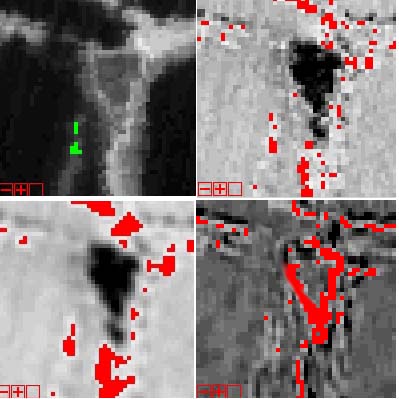
As an example of this work a sub-image from Bakers Rendezvous is shown. The image is cloud-free. The black area in the middle of Fig. 1b-1d is an island, and the red pixels in and in close relation to this area should be excluded from the analysis. The interpretations from the earlier analysis are very well represented in all result images except in 1e. The second principal component is quite similar to the difference image. There are four large areas in Figure 1c, except the one corresponding to the field observations. Looking at the original subimages, the general impression is that the reef has "expanded" in these areas, rather than that a few pixels have become brighter in comparison to the surrounding pixels. This might be a result of the resampling method used (cubic convolution), for the image from August.
Figure 1a-1e. Subimage including interpretations, difference image (10), difference image after mean filtering (5), PC-2 (7) and local texture difference (5). Figures within brackets gives differences in DN.